LiDAR (Light Detection and Ranging) sensors have emerged as a transformative technology for unmanned aerial vehicles (UAVs), enabling high-precision 3D mapping, surveying, and inspection across numerous industries. Unlike traditional photogrammetry, LiDAR operates by emitting rapid laser pulses and measuring the time it takes for each pulse to reflect off a surface and return to the sensor. This direct measurement method allows it to generate accurate point clouds even in low-light conditions and through light vegetation, making it invaluable for applications ranging from topographic surveys and forestry management to infrastructure inspection and autonomous navigation.
The core components of a drone-mounted LiDAR system include the laser scanner itself, a high-accuracy GNSS (Global Navigation Satellite System) receiver, and an Inertial Measurement Unit (IMU). The GNSS provides the absolute position of the drone, while the IMU records its precise orientation (roll, pitch, and yaw) at a very high frequency. The data from these three systems are synchronized and processed through a method called direct georeferencing. This complex integration is what allows the system to assign highly accurate real-world coordinates (X, Y, Z) to each individual laser point, creating a geospatially correct 3D model. The choice between different types of LiDAR—such as discrete-return, full-waveform, or solid-state—depends heavily on the specific application and required point density.
For engineering and surveying professionals, the key specifications that define a LiDAR sensor's performance are its measurement accuracy, pulse repetition frequency (PRF), and scan rate. Accuracy, often in the centimeter range, is paramount for creating reliable digital terrain models (DTMs). The PRF, measured in kilohertz, determines how many laser points can be collected per second; a higher PRF allows for denser point clouds and faster coverage. The scan rate, or the speed at which the laser beam is deflected (often via a rotating mirror or oscillating mechanism), influences the swath width and point distribution on the ground. Modern systems also feature multiple returns, meaning they can capture the first, second, third, and last return from a single pulse. This capability is crucial for differentiating between tree canopies, branches, and the ground surface in forestry applications, or for modeling complex structures like power lines and their surroundings.
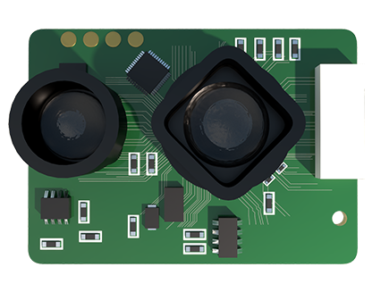
The operational advantages of drone-based LiDAR are significant. UAVs can access hazardous or difficult-to-reach areas, such as steep slopes, quarries, or dense forests, with minimal risk and environmental impact. They collect data far more rapidly than terrestrial laser scanners or manual survey teams. A single flight can cover hundreds of hectares in a day, producing a massive dataset ready for processing. However, successful deployment requires careful mission planning. Flight altitude, speed, and line spacing (overlap) must be optimized to achieve the desired point density and accuracy. Weather conditions, particularly wind and precipitation, can affect data quality and flight safety. Furthermore, the raw data requires extensive post-processing using specialized software like TerraSolid, LAStools, or proprietary vendor suites to classify points, filter noise, and generate final deliverables such as contour lines, volume calculations, or 3D models.
Looking forward, the evolution of LiDAR technology for drones is focused on miniaturization, cost reduction, and increased intelligence. Solid-state LiDAR sensors, which have no moving parts, promise greater durability and lower costs for smaller drones. The integration of LiDAR with other sensors, like high-resolution RGB or multispectral cameras, in sensor fusion systems is creating richer datasets. Perhaps most importantly, LiDAR is a critical enabler for advanced drone autonomy, providing the real-time, high-resolution environmental perception needed for beyond visual line of sight (BVLOS) operations and obstacle avoidance in dynamic environments. As processing power increases and algorithms become more sophisticated, we are moving towards real-time onboard point cloud processing, which will unlock even faster insights and decision-making capabilities in the field.
In conclusion, LiDAR sensor technology is a cornerstone of modern professional drone capabilities. Its ability to deliver precise, reliable, and rich geospatial data is driving efficiency and innovation in surveying, construction, agriculture, and energy sectors. For engineers and operators, a deep understanding of the system's principles, specifications, and operational workflows is essential to harness its full potential and deliver projects with the highest standards of accuracy and detail.