LiDAR, an acronym for Light Detection and Ranging, has rapidly evolved from a specialized surveying and military technology to a cornerstone of modern autonomous systems, robotics, and environmental mapping. For students and electronics enthusiasts, understanding LiDAR is no longer just an advanced topic—it's becoming fundamental. Educational LiDAR sensors bridge the gap between complex industrial systems and hands-on learning, providing an accessible platform to explore the principles of time-of-flight measurement, point cloud generation, and sensor fusion.
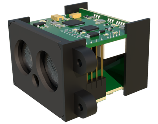
At its core, a LiDAR sensor measures distance by emitting laser pulses and calculating the time it takes for the light to reflect off a surface and return to the detector. Educational versions of these sensors simplify the underlying technology into a manageable package, often featuring a single scanning or solid-state module, a microcontroller interface, and supportive software libraries. Unlike their automotive or industrial counterparts, which prioritize long-range, high-resolution, and ruggedness, educational LiDAR sensors emphasize clarity of operation, programmability, and safety, typically using Class 1 eye-safe lasers.
The typical educational LiDAR setup involves a rotating or fixed sensor head. Common models include 2D LiDARs that scan in a single plane (like the RPLidar A1 or YDLIDAR models) and simpler, non-scanning time-of-flight modules (like the TFMini or VL53L1X). These devices connect to development boards such as Arduino, Raspberry Pi, or ESP32 via UART, I2C, or USB. The first experiment for any learner is usually interfacing the sensor: writing code to read raw distance values. A simple Arduino sketch can capture the distance to an object in centimeters, laying the groundwork for understanding the basic data output.
The real educational power of LiDAR unfolds in data visualization. Raw distance numbers transform into meaningful spatial information when plotted. Using processing environments like Python with libraries such as Matplotlib or Pygame, students can convert sequential distance measurements at known angles into a 2D polar plot. Watching a simple line trace the outline of a room on a screen, generated from real sensor data, is a profound moment that cements understanding of scanning mechanics and coordinate transformation.
From basic ranging, projects can increase in complexity. A natural progression is building a simple robot capable of obstacle avoidance. By mounting a 2D LiDAR on a servo for tilt or using a scanning model, the robot can build a rudimentary map of its immediate surroundings and navigate autonomously. This project introduces critical concepts in robotics: sensor integration, real-time data processing, and reactive control algorithms. Another excellent project is creating a security scanner that monitors a doorway or area, triggering an alert when the predefined spatial profile changes, demonstrating application in perimeter monitoring.
Perhaps the most significant conceptual leap is from 2D scanning to understanding 3D point clouds. While true 3D LiDAR is expensive, educational approaches often involve attaching a 2D scanner to a moving platform or a second servo axis. By scanning in one plane and then incrementally changing the pitch, a dense set of points in three-dimensional space can be collected. Software like CloudCompare or even simple Python scripts can then visualize these points, introducing learners to the data format that powers self-driving car perception and digital twin creation.

Working with educational LiDAR also presents valuable lessons in sensor limitations and noise. Students quickly observe that performance varies with surface material (black surfaces absorb light, reducing range), ambient light (though less than cameras), and incidence angle. Learning to filter data—applying median filters to remove spurious noise or setting valid range thresholds—is an essential engineering skill. It teaches that sensor data is never perfect and that robust systems require intelligent software processing.
The ecosystem supporting educational LiDAR is rich. Open-source software frameworks, notably the Robot Operating System (ROS), have dedicated drivers and tutorials for popular educational LiDAR models. Using ROS, students can integrate their LiDAR data with other simulated or real sensors, run sophisticated Simultaneous Localization and Mapping (SLAM) algorithms, and control robots in a standardized, industry-relevant environment. This exposure provides a direct pathway to advanced research and professional development.
In conclusion, educational LiDAR sensors are powerful tools that demystify a transformative technology. They enable a hands-on curriculum that progresses from basic serial communication to advanced topics in robotics perception and 3D data analysis. By lowering the barrier to entry, these devices are cultivating the next generation of engineers and developers who will innovate in autonomous vehicles, smart infrastructure, augmented reality, and beyond. The journey from a blinking LED on a breakout board to generating a map of your workshop is a comprehensive lesson in modern mechatronics and computational sensing.