Laser scanning rangefinder sensors represent a pivotal technology in modern measurement and spatial data acquisition. These devices operate by emitting laser pulses toward a target and calculating the distance based on the time it takes for the light to reflect back to the sensor. Unlike single-point rangefinders, scanning variants incorporate a mechanism—often a rotating mirror or a moving sensor head—that sweeps the laser beam across a field of view. This allows for the rapid collection of thousands or even millions of distance points, creating detailed two-dimensional or three-dimensional point clouds of the environment.
The core principle behind these sensors is Time-of-Flight (ToF) measurement. A laser diode emits short, focused pulses of light. A high-precision clock measures the interval between emission and the detection of the reflected signal by a photodetector. Given the constant speed of light, the distance to the object is calculated with remarkable accuracy. Advanced models utilize phase-shift measurement for even higher precision at shorter ranges, analyzing the phase difference between the emitted and returned continuous-wave laser signal.
The scanning mechanism is what truly defines this technology. Galvanometer-based scanners offer high speed and accuracy for controlled environments, while rotating polygon mirrors or continuous 360-degree rotating heads are common in mobile and outdoor applications like LiDAR on autonomous vehicles. The angular resolution of the scan—determined by the step angle of the mechanism—directly impacts the density and detail of the resulting point cloud.
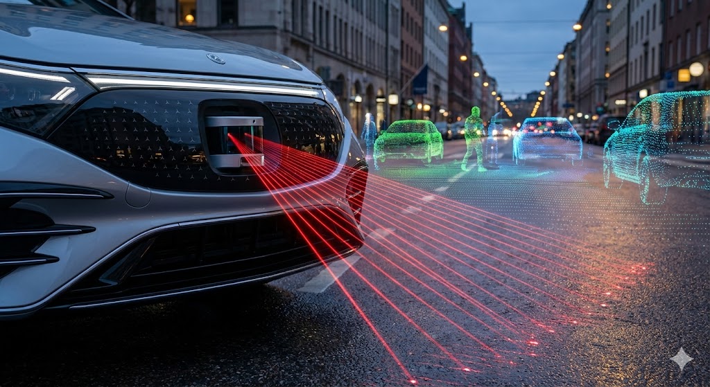
Applications for laser scanning rangefinder sensors are vast and transformative. In industrial automation, they are integral for robotic guidance, bin picking, and volume measurement. They enable robots to perceive their workspace in 3D, identifying object position, orientation, and size without physical contact. In the realm of surveying and construction, terrestrial laser scanners create precise as-built models of structures, monitor structural deformation, and assist in complex renovation projects.
The automotive industry relies heavily on this technology for the development of autonomous driving systems. Automotive LiDAR sensors, a specialized form of laser scanning rangefinder, continuously scan the vehicle's surroundings to detect and classify obstacles, pedestrians, and other vehicles, creating a real-time 3D map for the vehicle's navigation system. Furthermore, in forestry and agriculture, these sensors are used for canopy height modeling, biomass estimation, and monitoring crop health from airborne platforms.
Key performance parameters include measurement range, scanning speed, angular resolution, and accuracy. Long-range sensors used in topography can measure over several kilometers, while short-range industrial sensors focus on sub-millimeter accuracy. Environmental factors such as ambient light, rain, fog, and the reflectivity of the target surface can influence performance, prompting designs with adaptive power settings and sophisticated signal filtering algorithms.
Recent advancements are pushing the boundaries of what's possible. Solid-state LiDAR, which eliminates moving mechanical parts, promises greater durability, smaller form factors, and lower costs—critical for mass-market adoption in consumer vehicles. Improvements in semiconductor technology are also leading to more sensitive detectors and more powerful, eye-safe laser sources. The integration of scanning rangefinder data with other sensor inputs like cameras and inertial measurement units (IMUs) through sensor fusion algorithms is creating richer, more reliable environmental models.
Looking ahead, the trajectory points toward miniaturization, enhanced intelligence at the edge, and seamless integration into the Internet of Things (IoT). As processing power increases and costs decrease, laser scanning rangefinder sensors will become ubiquitous, embedded in everything from consumer drones and smart home devices to advanced security systems and urban planning tools. Their ability to deliver precise, quantitative spatial data in real-time makes them a cornerstone technology for an increasingly automated and data-driven world.