In the rapidly evolving world of FPV (First-Person View) drone racing and freestyle flying, the demand for greater autonomy, obstacle avoidance, and precise navigation is pushing the boundaries of onboard sensor technology. Among the most significant advancements is the integration of LiDAR (Light Detection and Ranging) sensors. These sophisticated devices are transforming FPV drones from purely manually piloted craft into intelligent platforms capable of perceiving their environment with remarkable accuracy.
Unlike traditional camera-based systems or ultrasonic sensors, LiDAR operates by emitting rapid pulses of laser light and measuring the time it takes for each pulse to reflect off a surface and return to the sensor. This Time-of-Flight (ToF) principle allows for the creation of highly detailed, three-dimensional point cloud maps of the surrounding environment. For FPV applications, this translates to millimeter-level precision in distance measurement, independent of lighting conditions. A pilot flying through a dimly lit warehouse or a sun-dappled forest can rely on LiDAR for consistent data, where visual cameras might struggle with contrast or low light.
The core technical advantages of LiDAR for FPV drones are multifaceted. First is ranging accuracy and resolution. High-performance LiDAR modules designed for drones can achieve centimeter or even millimeter accuracy at ranges relevant to drone flight (typically from a few centimeters up to several tens of meters). This is critical for tasks like proximity flying, where knowing the exact distance to a gate or wall is paramount. Second is high update rate. Modern compact LiDAR sensors offer refresh rates exceeding 100 Hz, which is essential for high-speed drones where the environment changes in a blink of an eye. This fast data acquisition allows the flight controller to make real-time adjustments.
Third, and crucially, LiDAR provides direct distance measurement without the computational overhead of feature matching or stereo vision algorithms required by cameras. This reduces latency in the perception pipeline, a vital factor for maintaining stability and responsiveness at high speeds. However, integrating LiDAR is not without challenges. The primary constraints are size, weight, and power (SWaP). The FPV community is notoriously weight-sensitive; every gram counts for agility and flight time. Engineers are continually developing smaller, lighter solid-state LiDAR solutions that consume less power than their mechanical rotating counterparts. Another consideration is data processing. The stream of distance points must be efficiently interpreted by the flight controller's firmware or a companion computer to generate actionable commands for obstacle avoidance or autonomous navigation.
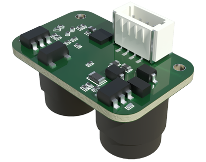
Current applications in the FPV sphere are already demonstrating LiDAR's potential. In drone racing, experimental systems use LiDAR for precise gate detection and automatic trajectory correction, assisting pilots in maintaining the optimal racing line. For cinematic and inspection drones, LiDAR enables advanced features like terrain following, where the drone autonomously maintains a constant height above uneven ground, and 360-degree collision avoidance, creating a protective bubble around the aircraft. Furthermore, LiDAR is indispensable for autonomous mapping and surveying with FPV platforms, allowing for the rapid creation of accurate 3D models of structures, landscapes, or accident sites.
Looking forward, the convergence of LiDAR with other sensors like high-frame-rate cameras and inertial measurement units (IMUs) in sensor fusion systems promises even greater robustness. Artificial intelligence and machine learning algorithms will leverage LiDAR point cloud data not just to see obstacles, but to classify them—distinguishing between a tree branch, a net, or a solid wall—and predict trajectories. This paves the way for truly intelligent FPV drones capable of complex autonomous missions in GPS-denied environments, such as indoor industrial inspections or search-and-rescue operations in collapsed buildings.
In conclusion, LiDAR sensor technology represents a paradigm shift for FPV drones, moving beyond human vision limitations to provide a reliable, precise, and fast digital perception of the world. While challenges in miniaturization and cost persist, ongoing innovation is steadily integrating these powerful eyes into the heart of FPV systems. For engineers, pilots, and enthusiasts, mastering LiDAR integration is key to unlocking the next generation of high-performance, intelligent, and autonomous FPV flight.